These offer great potential, and allow for much safer flights. Indeed, by knowing accurately the weather conditions around an airplane, it can avoid storms and high precipitation. Storms are usually places of great turbulences, and heavy rains aren’t the ideal flight conditions.
But let’s go back in time a little bit, in the early days of flight. During the first decades of aviation, at the beginning of the 1900s, flights were done when possible, this means with good weather and high visibility. No flying during storms, and no night flights. The addition of multiple instruments would enable night flights, but taking off during or towards a storm still wasn’t feasible.
In 1914, the US weather Bureau was founded, which would be later replaced by the NOAA’s (National Oceanic and Atmospheric Administration’s) Weather Service. This bureau would be in charge of providing weather status to pilots, relying at first mostly on ground stations. These stations would give different data like temperature, pressure, wind force and direction, rain density, etc. Technology getting better and better, more options became available, and more accurate measurements were made. For example, in 1931 regular flights would take off at 5am as high as 16,000ft (4,875m) to get visual information of the weather. In 1937, balloons were fitted with radiosondes, that would take off and send data back to the ground. At first these would gather basic data such as air temperature, humidity or pressure.
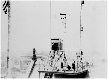
This is a weather station on top of a Weather Bureau, in 1925
The first weather radars were of course ground based, and appeared after WWII. Everything actually starts during the war, when many radar operators noticed some strange echoes that were not aircrafts. Investigations found out that these were caused by weather phenomenon such as rain droplets. To understand this effect let us see how radar works.
Radar, which stands for RAdio Detecting And Ranging is a device mostly used to know the distance and position of objects (but more advanced can give other information like direction, motion, angle, speed, etc.) that uses electromagnetic waves, in particular radio waves. A radar works in two phases, there are constantly repeated: an emitting and a listening phase. Basically a radar will send a wave pulse for a very short amount of time (around a micro-second), then go silent and listening for a period of time about one thousand times longer (so a millisecond); and then start again.
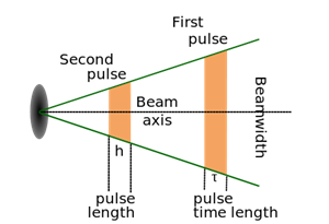
Here we can see a first pulse (orange) then the radar going silent, and sending a second pulse after. (the durations are not to scale)
The pulse is sent in one direction (the field of view depends on the radar), and if the radio wave hits any object (a plane, a bird, a droplet, etc.) then the wave will bounce on it and head back towards the radar. While silent, the radar listens to these echoes, and these are the objects that will be seen. The bigger the object, the more waves will be echoed, so the bigger the spot of the screen.
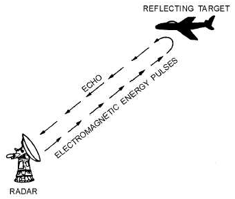
The pulse is sent, and here we can see it bounces off the plane, heading back to the radar.
All the waves sent that don’t bounce off anything will just go and never come back to be heard by the radar. This principle allows us to know that there is something, but how do we actually know how far it is? Well here is where a little math comes it. The radio waves are a sort of electromagnetic waves (like visible light), so they travel at the speed of light, which is constant and that we know very precisely, which we call the celerity, noted c. So by having a very accurate clock inside the radar, by knowing the time it takes the pulse to go, bounce and come back to the radar, we can measure the distant at which the object is. One of the simplest physics equations is:
![]()
Though we want the distance, so we can simply turn this equation around and end up with:
![]()
We know the speed of the wave; it’s the speed of light, that we call c. And we know the time, thanks to our very accurate clock. The only thing not to forget is that the wave went back, and forth, so it travelled twice the distance at which the object is. We simply have to divide the time by two, and we can know very precisely the distance at which the object is from our radar. Then to know which direction the object is, you simply have to make the radar rotate on itself, so that it looks all around. This is why radars usually have a very narrow field of view, because they can only give distance (at least for these example, which are called primary radars), not direction. So you know the object is at a certain distant, in the direction where the radar is pointing towards. By making the radar rotate, we have a 360° field of view.
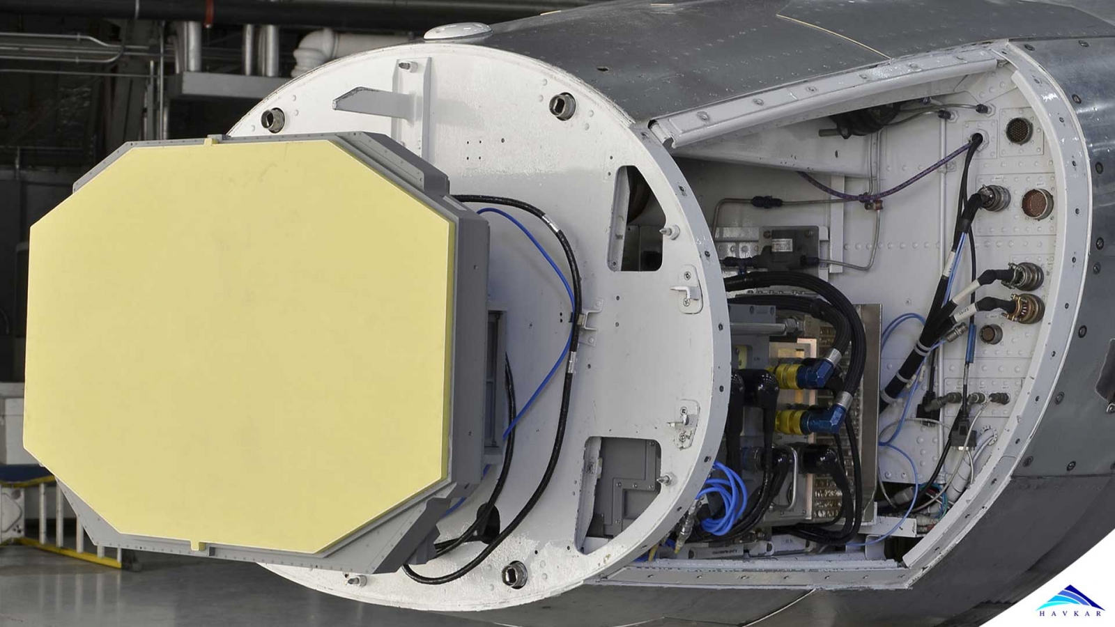
Now for weather radars, they work exactly the same way, except that they are looking for smaller object then say airplanes, they try to look for rain drops. A big amount of rain droplets can mean rain, or big clouds like cumulonimbus. Airborne weather radars are usually fit in the nose of the aircraft, and do not rotate on a full 360° angle. They instead only “see” in front of the airplane, which is roughly the direction where it is heading, most of the time.
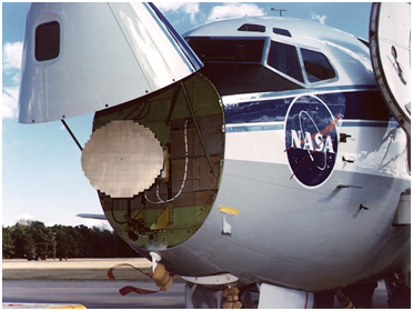
Here is an airborne weather radar's antenna in the nose of a NASA B737.
Since the first use of airborne weather radar in 1955, such tools have come a long way. Nowadays weather radars are more and more complex, and give better and more accurate data, always providing better knowledge of the situation to the pilots.
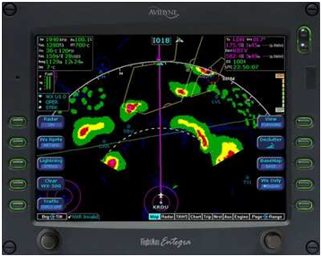
This is a picture of what onboard weather radar display look like.
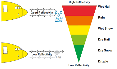
The green parts indicate low reflection, and red high reflection.
Having onboard weather radars doesn’t mean there isn’t any ground based weather centres anymore. These are in fact very important, because they can now provide forecast, and give an insight on the weather to come, which routes to take, etc. Onboard radar provides relatively close range data to the pilots, to have a good idea of what is ahead of them, whereas ground station (with the help nowadays of satellites) provides a more general view of the weather.
 What Are Seaplanes And Their History Of Development ?
 Interesting Facts You Never Knew About Commercial Aircrafts And Aviation
 Extended Ground Proximity Warning System - EGPWS
 Airspace Classifications And The Air Traffic Control Services
 How An Instrument Landing System ( ILS ) Works
 EFB (Electronic Flight Bag)
 All About Aviation Fuels